Chapter 7 Flight Safety Guidelines
All UAS activity must develop a comprehensive flight safety plan.
7.1 Site Assessment
UAS safety typically falls under two categories: (1) Planned Safety and (2) On-site threats. The UAS activity review process includes a review of Planned Safety to ensure that the RPIC is aware of potential risks and has procedures to mitigate risks.
Not all potential safety considerations may be applicable. Many risks associated with UAS activity can be mitigated by selecting operating locations where a UAS incident or accident would be unlikely to cause an injury.
7.1.1 Planned Safety
The RPIC must plan for the safety of the UAS activity by evaluating to the best of his or her ability, the following potential impacts:
- Type of airspace, restricted flight areas
- Any applicable Temporary Flight Restriction (TFR) or NOTAM
- Hazards associated with the location, such as roadways, powerlines, towers
- Local laws or ordinances
- Obstructions (wires, structures, buildings, etc)
- Pedestrian or bicycle pathways, public access and access points (common doorways or entrances)
- Identifying alternative emergency contingency or recovery sites
- Weather conditions by consulting with weather forecasts online
After evaluating the site, the RPIC is responsible for developing a suitable flight plan and hazard mitigation plan (as appropriate).
The following information is expected within a Site Assessment or description of hazards and hazard mitigation plan as submitted with a UAS Activity Request Form:
- Narrative of the proposed operation
- Flight altitudes
- Marking of buffer or safe-zones
- Specific flight paths
- Emergency procedures
- Identified emergency or contingency locations
- Crew management (including roles and responsibilities)
- Procedures to manage crowds or spectators
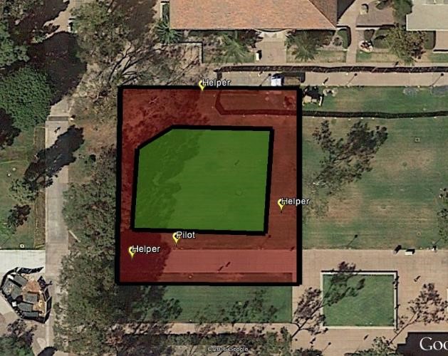
Figure 7.1: Mapping out helpers at UCSB
7.1.2 On-site Threats
There are many on-site threats to UAS safety that are not always feasible to be reviewed. It is the responsibility of the RPIC to ensure a safe operating environment, from ensuring the unmanned aircraft is suitable for operation to managing intrusions and weather conditions.
Example On-site Threats
Weather conditions
Structures not visible from satellite imagery, such as
- Powerlines or telephone poles
- Recent construction
- Temporary structures
Intruding air traffic
Intruding pedestrians or other non-participants, including wildlife
unmanned aircraft damage
Unplanned spectators or crowds
7.1.3 Weather
Local weather must be checked prior to UAS activity to ensure wind speeds, precipitation, temperature or other environmental factors will not adversely affect the safety of the UAS activity. This information should then be re-checked during the on-site survey, prior to take-off. No UAS activity shall occur when weather conditions exceed VFR Weather minimums or the listed aircraft tolerance per the manufacturer’s manual.
7.1.4 Site Permissions
All UAS activity at a University Location must have prior authorization, accomplished via the UAS Activity Request Form. If additional authorization is required by a managing entity (campus recreation, Natural Reserve Site Director), it shall be obtained in coordination with the Designated Local Authority or Systemwide Designated UAS Authority. At off-site locations, site permissions shall be obtained as necessary. The UC shall maintain good neighbor relations with all public entities and shall abide by the processes or restrictions as directed.
Common Public Land
- California State Parks - contact the Park Director
- Other California State Agency Land - contact the site director
- National Forest (excluding Wilderness Lands) - No authorization necessary
For UAS activity, the RPIC shall obtain site permission to the best of his or her ability for all property the UAS activity will occur above.
7.2 Safety Guidelines
- UAS activity should always establish a buffer or safe-zone between the unmanned aircraft and any non-participating persons or sensitive locations.
- A good rule-of-thumb is to maintain a buffer or safe-zone of roughly \(\frac{1}{4}^{th}\) of the flight altitude.
- Visual Observers and supporting ground crew should be utilized when available.
- Supporting ground crew should assist in ensuring safety to all non-participating persons.
- High visibility reflective vests should be utilized when operating near roads or when near non-participants (Figure 7.2).
- Whistles are effective for alerts or other time-sensitive communication.
- Orange cones may be used to help communicate unmanned aircraft flight regions to non-participating persons, but are not fully sufficient.
- If spectators are expected, a supporting ground crew member should be tasked with preventing spectators from distracting the RPIC with questions or comments.
- When operating in uncontrolled locations in proximity to non-participating persons, extra care should be exercised. Specific flight paths and altitudes should be pre-planned such that potential gaps in buffer or safe-zones can be identified.
- When operating near roads, a supporting ground crew member should be tasked with being located near the road to monitor traffic, and if necessary, retrieve a fallen unmanned aircraft before it becomes a road hazard.
- When operating in fenced areas, operate exclusively within the fenced areas unless there is sufficient visibility on the other side to ensure safety to non-participants.
- Flying above buildings and structures minimizes risk to pedestrians, but it is recommended to contact the facility manager to explain the proposed operation and potential for risk.

Figure 7.2: UAS Operators with High Visibility Reflective Vests